.webp&w=1920&q=82)
.webp&w=1920&q=82)
.webp&w=1920&q=82)
.webp&w=1920&q=82)
.webp&w=1920&q=82)
.webp&w=1920&q=82)
.webp&w=1920&q=82)
.webp&w=1920&q=82)
.webp&w=1920&q=82)
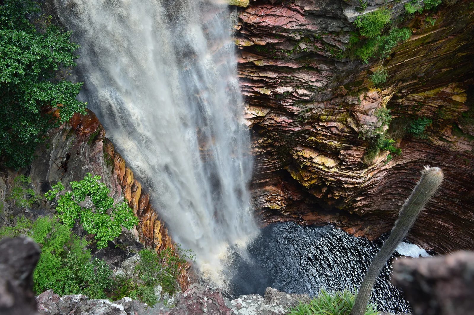
Cachoeira do Buracão
Cachoeira do Buracão, Parque Natural Municipal do Espalhado
Municipal Natural Park of the Spread, about 29 km (18 mi) from the seat of Ibicoara, in the south-southwest sector of Chapada Diamantina.
Between the rock walls of Chapada Diamantina — a highland tableland with escarpments — Cachoeira do Buracão offers an unusual arrival: visitors enter by river, protected by a life jacket, and drift toward a waterfall roughly 85 meters (279 ft) (279 ft) high.
The route through Espalhado Municipal Natural Park alternates a rural road, hiking, and an aquatic finale in the canyon. After lookouts, stairways, and stretches beside the Espalhado River, cold water and the pool beneath the falls turn the exertion into an experience of monumental scale.
🤔 Why does it matter?
It is the main attraction of Ibicoara and a striking expression of nature tourism in Chapada Diamantina. The visit accompanied by local drivers associates enjoyment of the landscape, community economy and management rules for a sensitive use environment.
📍 What to see
- The free fall of approximately 85 meters (279 ft) framed by the rocky wall.
- The top lookout, where you can tell the depth of the valley.
- The corridor of the canyon illuminated variablely throughout the day.
- Waterfall of Orchids and Waterfall of Recanto Verde, when integrated to the chosen circuit.
- The forest near the River Spread and the outcrops of stone on the way.
🎒 Things to do
- Walk with driver registered by authorized route.
- Float in the final stretch using the vest provided in the visitation service.
- Swim in the well only when the driver is released.
- Photograph the canyon with waterproof camera or mobile protection.
- Observe birds and details of vegetation without leaving the trail.
✨ Recommended experiences
- First visit: leave Ibibara early, walk the trail calmly, float and save time for bath before return.
- Photo script: Match the lookout, the shadows of the rocky corridor and the waterfall, carrying watertight bag and mini-trip.
- South Plated in two days: sleep in Ibibara or Mucugê, visit Buracão in one day and leave the nearby wells and waterfalls for the next.
- For those who do not feel safe in water: talk to the driver about the alternative of land passage in the final stretch and about the conditions of the day.
🍽️ Local cuisine
🎶 Soundtrack
- Refazenda — Gilberto Gil
- Preta Pretinha — Novos Baianos
- Capim-Guiné — BaianaSystem
🎭 Local culture
🌿 Nature nearby
🌎 Biomes
🏞️ Natural features
🐾 Possible animals in the area
🌱 Possible plants in the area
📅 Best time to visit
From June to September, the climate tends to be milder and the trail usually offers better balance between soil firmness and experience quality. Programming must always comply with the conditions communicated by drivers.
- ✅ Best time:
- June to September, for gathering drier weather, pleasant temperatures and greater predictability in access.
- 🟡 Shoulder season:
- March to May and October, when the fall may be more voluminous or the well lighter according to recent rain.
- 🔴 Less recommended:
- November to February, especially in episodes of intense rain, when the road, trail and canyon may have safety restrictions.
- 📝 Notes:
- There is no guarantee of bath or fluctuation on all dates. Heavy rain, increased flow and management or driver guidance can change the route.
🧭 Getting there
🏙️ Base city: Ibibara
✈️ Airport: Glauber Rocha Airport in Vitória da Conquista
- Use Ibibara as a base to reduce the displacement to the ordinance of the Municipal Natural Park of the Spread.
- From Vitória da Conquista, follow state highways to Ibibara and organize the final stretch in advance.
- Starting from Lençóis, plan a long day: operators indicate approximately 500 to 520 km (311 to 323 mi) of total displacement for the tour.
- The approach road may have unpaved stretches; confirm the conditions on the date of the trip.
🚗 Local transportation
- Hire previously driver or accredited guide, as follow-up is mandatory.
- Combine transport between Ibibara and the entrance of the park with inn, agency or local driver.
- In rainy season, evaluate vehicle suitable for rural road conditions.
ℹ️ Practical information
- 🏗️ Infraestrutura:
- basic in the park area and functional in the city-base
- 🏨 Hospedagem:
- Ibicoara concentrates family hostels; Mucugê and Lençóis expand the alternatives for those who ride script by Chapada.
- 🍴 Diet:
- There are simple restaurants and homemade kitchens in Ibibara; bring snacks and water for the ride.
- 🧭 Guides and agencies:
- Driving by visitor driver or accredited guide is required. Book in advance, especially on holidays and holidays.
- 📶 Internet and signal:
- Coverage inside the park was not confirmed by reliable source; does not depend on mobile connection during the trail.
- 💰 Estimated cost:
- The visitation rate appears from R $ 30 per person in the scheduled system consulted. The local driver is hired separately; transportation, insurance and food vary according to the route.
- 📝 Notes:
- Price, availability, time and limit of visitors are operational and must be confirmed in the schedule of the desired date.
♿ Acessibilidade
Level: not adapted for people with reduced mobility
The itinerary includes irregular terrain, stones, staircases, slopes and an aquatic stage in the canyon. There's no evidence of an accessible route to the waterfall.
- Inform previously mobility limitations, clinical conditions and water-related fears.
- Ask the driver for a realistic assessment of the day's alternatives before leaving the city.
- Use closed footwear with attached soles and avoid carrying unnecessary weight.
⚠️ Safety
🚨 Real risks
- slippery floor on stones and stairs
- sudden increase in flow after rain
- fatigue on irregular terrain
- swimming or floating in cold water
- delay of service in remote area
✅ Recommended care
- Follow the driver and do not proceed to the canyon without authorization.
- Use life jacket in the indicated stretch and keep away from the fall.
- Stop the walk in case of heavy rain or condition change warning.
- Bring water, sun protection, raincoat and personal health items.
- Keep garbage and food well packed to reduce the impact on the trail.
⛔ When to avoid: Avoid the visit when there is intense rain alert, park operating restriction, physical condition incompatible with walking and water, or absence of accredited driver.
📝 Checklist — what to bring
- Tennis or track boot with good grip
- Swimming clothes and changes dry for the lap
- Water, light snack and personal remedies
- Sun protector, cap, sunglasses and repellent
- Raincoat and light coat
- Waterproof bag for documents and electronics
- Identification document
✈️ Travel tips
- Book all day long and prefer to start early to enjoy the journey in less haste.
- Do not treat the value of an agency leaving Lençois as if it were the local rate of entry.
- Ask the driver about the crossing alternative available before starting the final stretch.
- Staying in Ibibara reduces road wear and allows adjusting the output to the climate.
- Use only the passages indicated and preserve silence in the fauna observation passages.
💡 Curiosidades
- The main walk adds up to about 6 km (3.7 mi) back and forth, usually traveled in 40 minutes to an hour per direction.
- The arrival stretch can be made by fluctuation with vest, an unusual way to reach the base of a great Brazilian fall.
- The Municipal Natural Park of the Spread has 612 hectares (1,512 acres) and protects the landscape near the Spread River.
🤔 Did you know?
- The water that feeds the waterfall is associated with the rivers Mucugezinho, Riachão and Jiboia, according to a study on the conservation unit.
- The visitation of the trail has already been the object of academic research on environmental impacts, with special attention to vegetation damage.
- The conservation unit is municipal, not part of Chapada Diamantina National Park.
📜 History and context
The Municipal Natural Park was created by Municipal Decree 015/2005 and occupies 612 hectares (1,512 acres) aimed at protecting natural attributes, recreation, environmental education and research. An academic study records that the discovery of the fall by hunters in 1998 boosted the tourism appreciation process of the area.
🌍 Global importance
The waterfall does not have a specific international designation confirmed. Its relevance goes beyond the municipality because it integrates the imaginary trips of Chapada Diamantina and because it shows how an attractive of great demand requires reconciling public access, qualified driving and ecosystem conservation.
🗺️ Quick map (orientation)
📌 Main base: Ibibara
🧭 Landmarks
📍 Nearby places
Pequenas descobertas
- BA
- Federative unit: Bahia.
- Orquídeas
- Neighboring waterfall, usually visited on return, with lookouts and shallow wells.
- Buracãozinho
- Neighbor fall, short trail and canyon look.
- Carne-de-sol
- Salted or cured meat, grilled on the plate or on the coal.
- Aipim
- Mandioca, macaxeira or aipim, dishes base of the Northeast.
- Beiju de tapioca
- Beiju or Tapioca stuffed, typical preparation of the North and Northeast.
- Umbu
- Fruit of the semiarid Bahian, bittersweet flavor.
- Guia credenciado
- Obligation to hire registered local driver.
- SSA
- Salvador International Airport.
- VDC
- Glauber Rocha Airport, Victory of the Conquest.
- Mini-tripé
- Simple support to stabilize camera or mobile at long exposures.
Keep discovering
Flavors
Beverages
Plants
Places
Culture