.webp&w=1920&q=82)
.webp&w=1920&q=82)
.webp&w=1920&q=82)
.webp&w=1920&q=82)
.webp&w=1920&q=82)
.webp&w=1920&q=82)
.webp&w=1920&q=82)
.webp&w=1920&q=82)
.webp&w=1920&q=82)
Cachoeira do Jatobá
Serra Ricardo Franco State Park, in Vila Bela da Santíssima Trindade, western Mato Grosso, near the border with Bolivia.
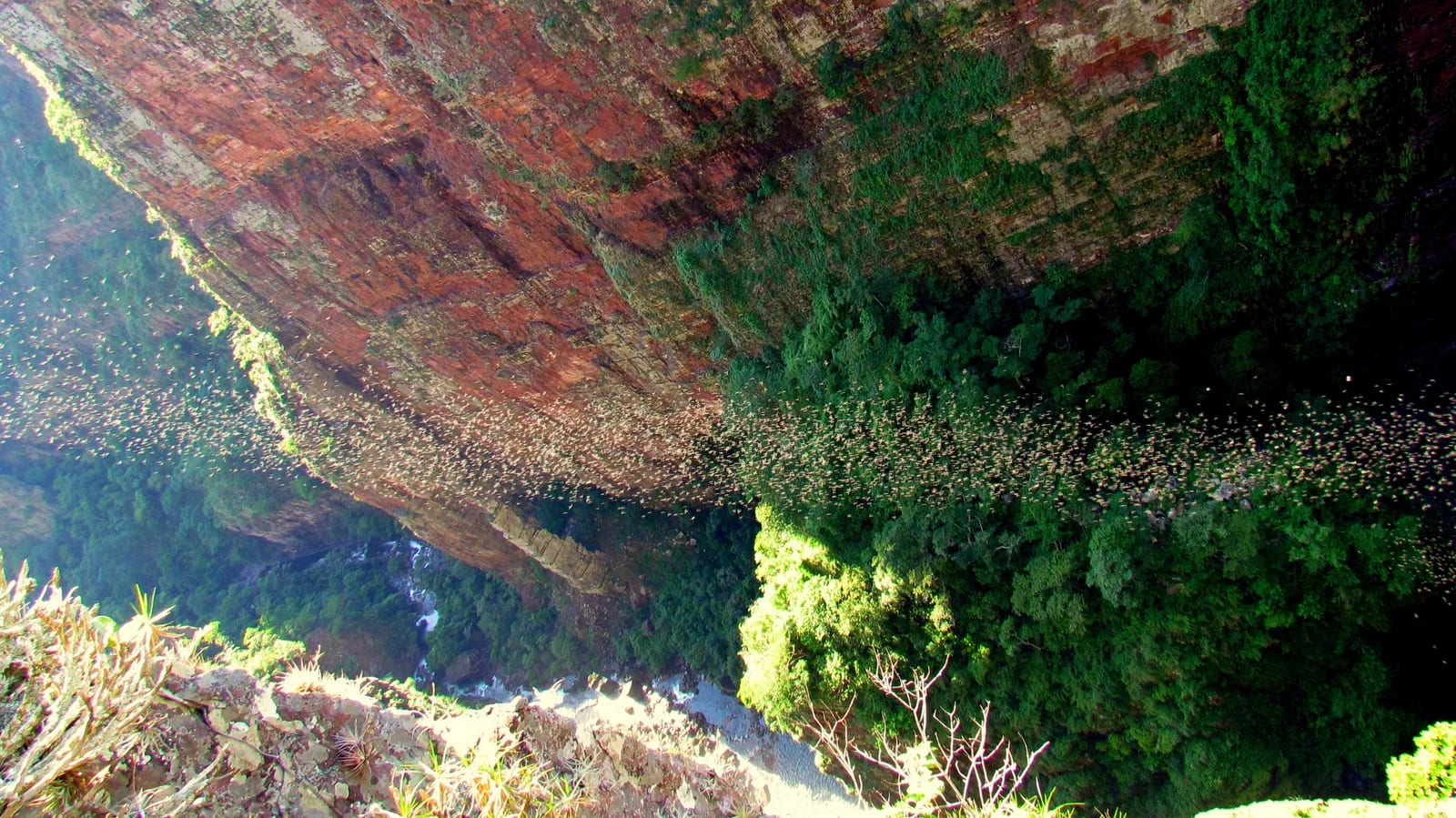
In western Mato Grosso, Cachoeira do Jatobá drops between the cliff walls of Serra Ricardo Franco and asks for stamina from those who reach it on foot. The effort opens onto a sweeping panorama of water, rock, and transitional vegetation.
Within Serra Ricardo Franco State Park, Jatobá forms a monumental fall set in a canyon, beneath grasslands, forests, and outcrops that express the environmental diversity of Vila Bela da Santíssima Trindade. The approach favors contemplation: the landscape unfolds at natural lookouts, with water descending ocher walls and the terrain lending scale to the hike.
🤔 Why does it matter?
Recognized by the municipal tourism authority as Mato Grosso’s largest waterfall, the attraction distills Serra Ricardo Franco’s ecotourism character. It is a journey for travelers who value demanding crossings and prefer preserved landscapes to ready-made infrastructure.
📍 What to see
- The main fall framed by rock walls
- The canyon carved by the local drainage system
- Natural lookouts facing the valley
- The variation between savanna, forest, and wetland environments
🎒 Things to do
- Follow the authorized hiking route to the waterfall
- Photograph the fall and cliff walls in sidelight
- Watch birds without leaving the marked path
- Assess the possibility of swimming on site, only where safety guidance is provided
✨ Recommended experiences
- A half-day itinerary: start early, focus on the walk to Jatobá, and allow time to take in the canyon before returning.
- A day in nature: pair the waterfall with another Serra Ricardo Franco attraction only after checking route conditions with a local professional.
- A two-day immersion: stay in Vila Bela, explore the historic center, and reserve the hike for a morning with a stable forecast.
🍽️ Local cuisine
🎭 Local culture
🌿 Nature nearby
🌎 Biomes
🏞️ Natural features
🐾 Possible animals in the area
🌱 Possible plants in the area
📅 Best time to visit
From June through September, the drier season usually favors more stable trails and clearer views from the lookouts.
- ✅ Best time:
- June to September
- 🟡 Shoulder season:
- April and May, when the transition from the rains may keep pools full, requiring route checks.
- 🔴 Less recommended:
- November to March, when heavy rain can alter road conditions, raise watercourses, and suspend activities.
- 📝 Notes:
- No public trail-opening calendar was found. Consult the municipality, the responsible management, and your guide before departure.
🧭 Getting there
🏙️ Base city: Vila Bela da Santíssima Trindade
✈️ Airport: Vila Bela da Santíssima Trindade Airport (MTG); confirm operating availability in advance. For scheduled connections, Marechal Rondon International Airport in Várzea Grande is the most commonly used alternative.
- From Cuiabá, the road route indicated by the city government passes through Cáceres on BR-070, then follows BR-174 toward Pontes e Lacerda, continuing to Vila Bela by state highway.
- The municipality’s attraction page provides a route map; use it as initial guidance and confirm rural access on the day of the visit.
🚗 Local transportation
- Arrange your own vehicle or a transfer from Vila Bela for rural sections.
- Plan transportation in advance with a guide or driver listed on the municipal tourism portal.
- Download maps and set a return plan before entering an area without reliable communication.
ℹ️ Practical information
- 🏗️ Infraestrutura:
- Basic in the base town and limited in the trail environment
- 🏨 Hospedagem:
- The municipal tourism portal lists hotels and guesthouses in Vila Bela da Santíssima Trindade; book ahead during event periods.
- 🍴 Diet:
- Restaurants and snack bars are registered in the municipality; bring water and a snack for activities outside the urban area.
- 🧭 Guides and agencies:
- The municipal portal maintains a register of guides and drivers linked to Cadastur. Confirm expertise, availability, and meeting point before traveling.
- 📶 Internet and signal:
- Mobile and data coverage inside the park was not confirmed by a recent operational source; be prepared to operate independently.
- 💰 Estimated cost:
- No recent public schedule for admission, guides, or transportation was found. Request a local quote and consider that the price varies by group, vehicle, and access conditions.
- 📝 Notes:
- No visiting hours, entry charge, or current capacity rules were found in the official source consulted.
♿ Acessibilidade
Level: consult local operators
No technical description of an accessible route was found. A 2018 technical study classified the hike as difficult.
- Discuss elevation changes, footing, and an alternative suited to your needs with a local driver in advance.
- Do not count on adapted infrastructure without direct, up-to-date confirmation.
- Bear in mind that rural travel may require boarding and disembarking on uneven ground.
⚠️ Safety
🚨 Real risks
- Difficult hiking sections and uneven terrain
- Slippery footing near water and rocks
- Exposed edges at lookout areas
- Rapid rise in water level after heavy rain
✅ Recommended care
- Wear hiking footwear with good grip and carry sufficient water.
- Stay on open routes and respect any local closure.
- Avoid approaching precipices or pools without an assessment of conditions.
- Tell someone your itinerary and expected return time.
⛔ When to avoid: Avoid visiting after heavy rain, with a severe-storm forecast, on compromised roads, or when local guidance suspends the trail.
📝 Checklist — what to bring
- Hiking footwear with grippy soles
- Water and food for the entire outing
- Sunscreen, hat, and insect repellent
- Light rain jacket or dry bag
- Basic first-aid kit
- Downloaded map and power bank
✈️ Travel tips
- Set out early to hike in cooler temperatures and return in daylight.
- Set aside at least two nights in Vila Bela to allow room for changes in weather or access.
- Plan for more than the attraction: the historic center adds cultural context to the experience.
- Do not assume free entry, fees, opening hours, or a mandatory guide without recent confirmation.
💡 Curiosidades
- The park’s municipal tourism page reports a vertical drop of 248 meters (814 ft) for Jatobá; another local institutional page gives a different figure, indicating the absence of a single technical reference.
- The orange-breasted falcon has been scientifically recorded near the waterfall’s headwaters.
- A technical study associated with SEMA-MT classified the hike to Jatobá as difficult and estimated, in 2018, that 9 km (5.6 mi) took about four hours.
🤔 Did you know?
- Vila Bela da Santíssima Trindade was Mato Grosso’s first capital during the colonial period.
- The ruins of the Mother Church in the town center belong to a project begun in 1793 and preserve thick adobe walls.
- The local Festança brings together brotherhoods that maintain religious and artistic practices passed down through generations.
📜 History and context
The destination lies within a state conservation unit created by Decree No. 1,796 of November 4, 1997. The waterfall’s name refers to the jatobá, a native tree associated with the region’s landscape, while Vila Bela preserves a colonial and Afro-Brazilian history that carries the journey beyond the trail.
🌍 Global importance
Serra Ricardo Franco occupies a meeting zone between the Amazon, the Cerrado, and the Pantanal, and at the western border it forms part of a neighborhood of protected areas reaching Noel Kempff Mercado National Park in Bolivia. This position gives the visit a transboundary conservation dimension, although the waterfall itself has no international heritage recognition.
🗺️ Quick map (orientation)
📌 Main base: Vila Bela da Santíssima Trindade
🧭 Landmarks
📍 Nearby places
Pequenas descobertas
- Parque Estadual da Serra de Ricardo Franco
- A state conservation unit in the far west of Mato Grosso.
- Cerrado
- A formation typical of Brazil’s Central-West, with wooded savannas, open grasslands, and gallery forests.
- Jatobá
- A native tree of the genus Hymenaea with dense wood; it inspired the waterfall’s name.
- Cachoeira dos Macacos
- A panoramic waterfall in the same hydrological system as Jatobá.
- Arco-Íris
- A waterfall with colored mist on sunny days, caused by refraction.
- Esmeralda
- A pool of translucent greenish water.
- Canela-de-ema
- An emblematic plant of rocky Cerrado, with a twisted stem and rosette leaves.
- Cânion do Jatobá
- A confined valley through which the Macacos River flows, with steep walls and sharp elevation changes.
- Farofa de banana
- Moist plantain farofa with spices, common in Mato Grosso.
- Pé-de-moça
- A creamy milk-and-peanut sweet, a Pantanal classic.
- Lambadão
- A musical and dance style typical of Cuiabá; it also names the area’s simple, generous cuisine.
- Escabeche de carne-seca com abóbora
- A creamy dish of dried beef and kabocha squash.
- Trombas d'água
- A flash flood or sudden surge in waterways after heavy rain.
- CGB
- Marechal Rondon International Airport in Várzea Grande, in the Cuiabá region.
- MT-199
- A state highway associated with access routes to the park.
- Desnível
- The route’s cumulative ascent, which requires physical fitness.
- Kit básico de primeiros socorros
- A kit containing gauze, bandages, antiseptic, pain reliever, and medical tape.