.webp&w=1920&q=82)
.webp&w=1920&q=82)
.webp&w=1920&q=82)
.webp&w=1920&q=82)
.webp&w=1920&q=82)
.webp&w=1920&q=82)
.webp&w=1920&q=82)
.webp&w=1920&q=82)
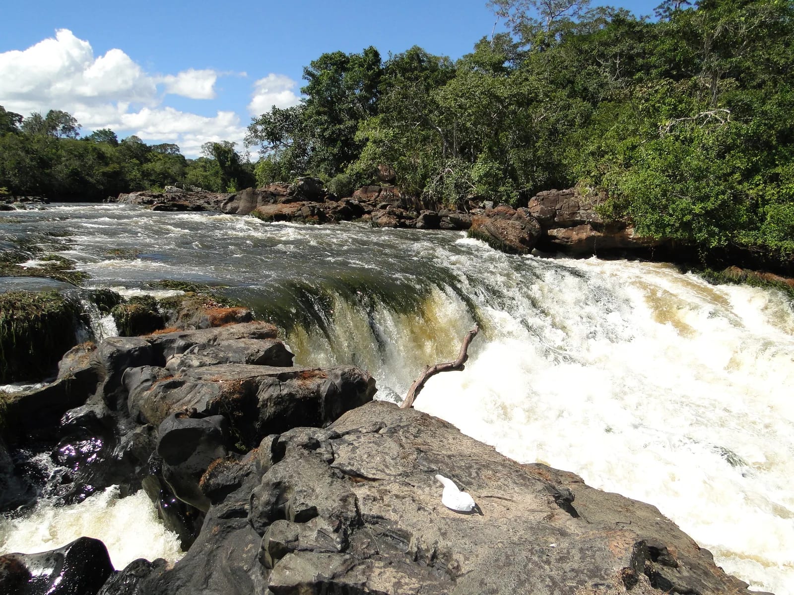
Cachoeira do Rio Cautário
Associated with the Cautário River, in the interior of the Rio do Cautário Extractive Reserve, in Guajará-Mirim, Rondônia. The coordinates indicate the base city, as no official reference for the specific waterfall was found.
More expedition than swimming spot, Cachoeira do Rio Cautário brings together current, rock, and Amazon rainforest in an area whose access depends on local logistics. It is a destination for unhurried observation, not for assuming services or permitted swimming.
Within the Rio do Cautário Extractive Reserve—a sustainable-use protected area—the watercourse runs through landscapes where rocky beds, rapids, terra firme forest, and rainforest alternate. The management plan recognizes waterfalls and caves as features of great scenic beauty and tourism potential, but it does not record an organized ecotourism offering. The experience depends on advance permission, the river level, community guidance, and the actual travel conditions.
🤔 Why does it matter?
When feasible and authorized, a visit offers a rare view of the protected Amazon beyond the immediate scenery: water runs through a sustainable-use territory shaped by extractive knowledge and by the responsibility not to turn a remote place into an attraction for quick consumption.
📍 What to see
- The contrast of flowing water, exposed stone, and forest canopy
- Rocky sections and rapids in the Cautário River system
- Terra firme forest beside incised waterways
- Outcrops and terrain associated with the reserve's sandstone complexes
🎒 Things to do
- Photograph without removing stones, fallen trunks, or lianas
- Listen to the current and recognize the sounds of water, insects, and forest
- Travel only on routes defined by those who know the territory
- Record the landscape without entering pools or rapids without guidance
✨ Recommended experiences
- A full-day expedition, arranged in advance, combining safe travel, contemplation of the waterfall, and a return before nightfall
- A nature-photography itinerary with a guide or authorized resident, prioritizing viewpoints that do not require clearing a path
- A conservation immersion that joins reading the river with an understanding of extractive activity and the reserve's community rules
🍽️ Local cuisine
🎶 Soundtrack
- Olhos de Rio — Bado
- Passarada — Bado
🎭 Local culture
🌿 Nature nearby
🌎 Biomes
🏞️ Natural features
🐾 Possible animals in the area
🌱 Possible plants in the area
📅 Best time to visit
From June to September, less interference from intense rain tends to favor logistics, but the decision to go must take into account authorization, the river, smoke, and local conditions that day.
- ✅ Best time:
- June through September, subject to community and operational confirmation.
- 🟡 Shoulder season:
- May and October, transition months that require checking side roads and water levels.
- 🔴 Less recommended:
- November through April, when rain and flooding can compromise access.
- 📝 Notes:
- The reserve has an equatorial, hot, humid climate, with three dry months recorded in CNUC. Seasonality does not replace a local safety assessment.
🧭 Getting there
🏙️ Base city: Guajará-Mirim
✈️ Airport: Guajará-Mirim Airport, GJM; confirm its operation and available connections in advance.
- Plan your arrival in Guajará-Mirim via Rondônia's road network or the local airport, according to available service.
- Before heading into the reserve's interior, consult ICMBio management and community contacts about permission, the meeting point, and departure conditions.
- There is no standard tourist route or confirmed public boarding point for the waterfall.
🚗 Local transportation
- Internal access may combine river travel, side roads, and routes guided by residents.
- Transport type, journey time, and passability vary with the season, river level, and local decision.
- Wear a life jacket on boat segments.
ℹ️ Practical information
- 🏗️ Infraestrutura:
- not set up for regular public visitation
- 🏨 Hospedagem:
- Seek lodging in Guajará-Mirim; no visitor-oriented lodging beside the waterfall has been confirmed.
- 🍴 Diet:
- Arrange provisions and meals in the base city; no food service has been confirmed at the site.
- 🧭 Guides and agencies:
- No agencies or guides operating regular public trips to the waterfall were found. Guidance from management and local communities is indispensable.
- 📶 Internet and signal:
- No coverage has been confirmed in the interior; bring offline maps, saved contacts, and a backup battery.
- 💰 Estimated cost:
- Not published. Transport, boat, and any local-agreement costs must be determined before departure.
- 📝 Notes:
- Reception, restrooms, signage, and ticket sales have likewise not been confirmed on site.
♿ Acessibilidade
Level: consult local operators
No technical accessibility assessment or adapted infrastructure for the journey was found.
- Communicate mobility, communication, or health needs in advance.
- Do not assume even ground, handrails, accessible restrooms, or adapted transport.
- Bear in mind that river travel and natural terrain may prevent safe participation.
⚠️ Safety
🚨 Real risks
- Slippery rocks and currents in a natural area
- River travel amid changing water levels
- Isolation and lack of regular transport in the interior
- Flooded access routes during the rainy season
- Smoke during fire season
✅ Recommended care
- Wear a life jacket in boats.
- Do not enter the water or proceed along igarapés without local guidance.
- Tell someone in the base city your itinerary and expected return time.
- Bring water, food, first aid supplies, insect repellent, a rain jacket, and contingency communication.
- Respect Brazil nut groves, community-use areas, and restrictions communicated that day.
⛔ When to avoid: Avoid leaving without authorization, during high water or intense rain, in dense smoke, when river travel is considered unsafe, or when the local person in charge advises against access.
📝 Checklist — what to bring
- Enough water and food for the journey
- Life jacket for boat segments
- Dry bag for phone and documents
- Extra battery and offline map
- Grip-soled shoes and quick-drying clothing
- Insect repellent, rain jacket, and first aid kit
- Local contact and return plan
✈️ Travel tips
- Confirm departure the day before, and accept route changes.
- Ask permission before photographing people, communities, or productive activities.
- Take all trash back with you.
- Favor compositions that use trunks and leaves as a frame, without disturbing vegetation.
- Do not promote the area as a swimming spot or promise swimming to other travelers.
💡 Curiosidades
- The management plan presents the name Guajará-Mirim as meaning small waterfall in Tupi-Guarani.
- The national register calculates the reserve's area at 75,125.03 hectares (185,638 acres) through geoprocessing.
- The management plan links waterfall formation to a steep hydraulic gradient and to benches controlled by the structure of the rocks.
🤔 Did you know?
- ICMBio's institutional page lists 75,124.93 hectares (185,637 acres) for the reserve, an administrative figure close to the national register's geospatial calculation.
- CNUC lists no published information in the reserve's annual visitors field.
- During the diagnostic stage that supported the management plan, organized public visitation had not yet been developed in the reserve.
📜 History and context
The Rio do Cautário Extractive Reserve was created by federal decree on August 7, 2001, to protect the livelihoods and culture of its extractive population while ensuring the sustainable use of renewable natural resources. The management plan, approved in 2017, treated public use as a possibility to be developed in keeping with local interests.
🌍 Global importance
As a federal sustainable-use protected area in the Amazon biome, the reserve is part of Brazil's network of protected areas, which brings conservation together with traditional subsistence practices. Its participation in the Amazon Protected Areas Program reinforces the territory's importance for long-term conservation, without implying that tourist infrastructure is in place.
🗺️ Quick map (orientation)
📌 Main base: Guajará-Mirim
🧭 Landmarks
📍 Nearby places
Pequenas descobertas
- RESEX
- Extractive Reserve: a sustainable-use protected area designed to safeguard the livelihoods and resources used by traditional populations.
- Encachoeirado
- A stretch of river with rapids, falls, or drops over rock.
- Vazante
- The stage when a river's level drops after high water.
- Floresta ombrófila
- A forest formation in a humid climate, with trees adapted to high moisture.
- Mata de terra firme
- Amazon forest in areas not regularly flooded by rivers.
- Castanha-da-amazônia
- The edible seed of the Brazil nut tree, a native Amazonian species also known as the Brazil nut.
- Tacacá
- A hot Amazonian broth made with tucupi, cassava starch, jambu, and, in usual versions, dried shrimp.
- Tucupi
- A yellow broth obtained from wild cassava, fermented and boiled before consumption.
- Igarapé
- An Amazonian watercourse, generally smaller than a river and often connected to larger rivers.
- Castanhal
- An area where Brazil nut trees occur and are managed for nut collection.
- Ramal
- A secondary road branching from a main highway to reach rural areas or communities.
- Bioma Amazônia
- A large group of Amazonian ecosystems recognized in Brazilian environmental classification.