.webp&w=1920&q=82)
.webp&w=1920&q=82)
.webp&w=1920&q=82)
.webp&w=1920&q=82)
.webp&w=1920&q=82)
.webp&w=1920&q=82)
.webp&w=1920&q=82)
.webp&w=1920&q=82)
.webp&w=1920&q=82)
Cachoeira do Tabuleiro
Tabuleiro District, 19 km (12 mi) from the town center of Conceição do Mato Dentro, in Serra do Espinhaço.
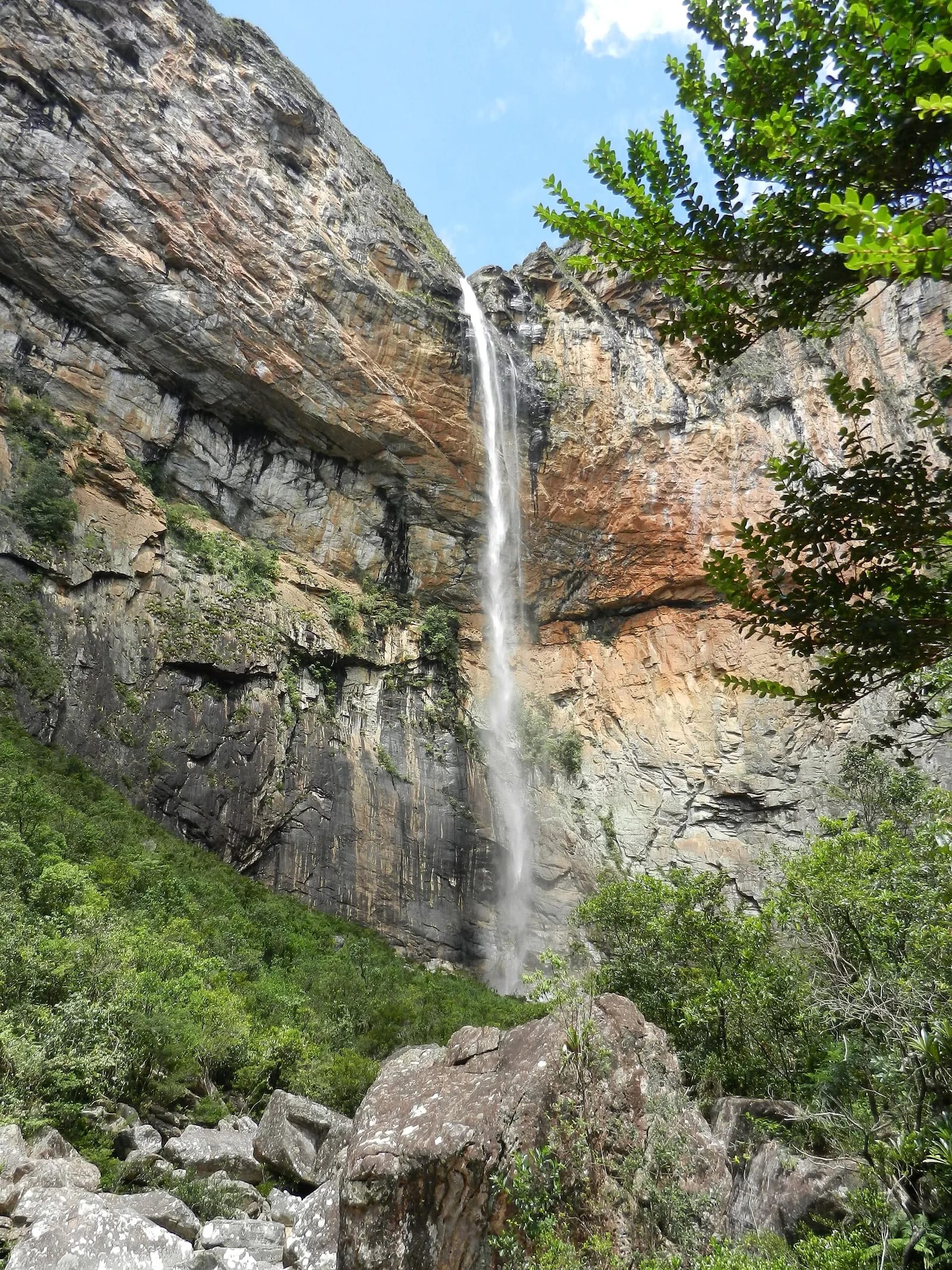
In Tabuleiro District, the great waterfall plunges before a cliff face that traces the silhouette of a heart. It is one of the most striking settings in Minas Gerais nature tourism.
In the heart of Minas Gerais, Cachoeira do Tabuleiro brings together water, rock and altitude in a landscape of campos rupestres—high-altitude grasslands with rocky outcrops. Its curtain of water falls before a multicolored wall, forming a large pool ringed by boulders at the foot of the massif; above, other pools and small waterfalls lie among bromeliads and orchids.
🤔 Why does it matter?
A visit reveals the scale of Serra do Espinhaço—a mountain range that runs north to south across Minas Gerais—and brings travelers closer to a community whose tourism economy is organized around conservation, hiking and contemplation. Today, the experience calls for planning: visitor protection takes precedence over access.
📍 What to see
- The waterfall and cliff face from viewpoints opened by the administration
- The park lookout point, when access is open
- Rocky vegetation, with outcrops and high-altitude flora
- The valley formed by Ribeirão do Campo before it joins the Rio Preto
🎒 Things to do
- Check the visitor-access status before setting out and obey installed barriers
- Travel only on officially authorized sections, at a pace suited to the terrain
- Photograph the landscape without leaving the designated areas
- Climb or rappel only with prior authorization and demonstrated technical qualification
✨ Recommended experiences
- A half-day of contemplation: confirm that the site is open, visit the permitted lookout point and allow time to observe the cliff face safely.
- A weekend itinerary: use Conceição do Mato Dentro as a base, visit Tabuleiro District and combine the attraction with other open sites in Serra do Espinhaço.
- A program for photographers: prioritize soft light, keep away from restricted areas and adapt framing to the conditions set by the park team.
🍽️ Local cuisine
🎶 Soundtrack
- Clube da Esquina nº 2 — Milton Nascimento e Lô Borges
- Dois Rios — Skank
- Primavera — 14 Bis
🎭 Local culture
🌿 Nature nearby
🌎 Biomes
🏞️ Natural features
🐾 Possible animals in the area
🌱 Possible plants in the area
📅 Best time to visit
For observation and hiking, the drier period usually brings less slippery ground; however, every visit depends on official authorization and the day’s safety conditions.
- ✅ Best time:
- May to September, generally with drier weather and better visibility.
- 🟡 Shoulder season:
- October and November, transitional months with more intense heat at midday.
- 🔴 Less recommended:
- December to March, when heavy rain increases the likelihood of suspension and makes trails more slippery.
- 📝 Notes:
- Seasonality does not replace operational notices: visitor access may be suspended because of rain, hydrological risk, geological risk, or an administrative or judicial decision.
🧭 Getting there
🏙️ Base city: Conceição do Mato Dentro
✈️ Airport: Belo Horizonte/Confins – Tancredo Neves International Airport
- From Belo Horizonte, the city government states that access is by road via MG-010 to Conceição do Mato Dentro, a journey of approximately 167 km (104 mi).
- From the municipal seat to Tabuleiro District, it is about 19 km (12 mi), following local signs.
- There are daily buses between Belo Horizonte and Conceição do Mato Dentro; confirm schedules and availability before traveling.
🚗 Local transportation
- From the district, the published reference is another 2 km (1.2 mi) by vehicle to the park headquarters.
- The historic route to the pool is about 3 km (1.9 mi) of trail and takes approximately 1 hour 30 minutes, but it should not be attempted without confirmation that it is open.
- A private vehicle or hired service makes travel on the rural stretch easier; assess road conditions after rain.
ℹ️ Practical information
- 🏗️ Infraestrutura:
- Basic, with the main services concentrated in the base town
- 🏨 Hospedagem:
- Conceição do Mato Dentro has the most established lodging options; the district has local businesses.
- 🍴 Diet:
- Restaurants and provisions are easier to arrange in the municipal seat; there is no current confirmation of food sales inside the park.
- 🧭 Guides and agencies:
- Technical activities require prior authorization and proven competence; favor qualified professionals and companies.
- 💰 Estimated cost:
- While visitor access was open, the most recent reference found listed R$10 for visitors from other towns, R$2 for visitors from Conceição do Mato Dentro and free entry for local residents. Charges should not be assumed during the closure.
- 📝 Notes:
- Pre-closure reference: open daily from 8 a.m. to 5 p.m., with specific entry times for each sector. On July 25, 2026, a judicial order closed the main pool and adjacent areas; confirm the situation and any operation of remaining sectors before traveling.
♿ Acessibilidade
Level: consult local operators
No up-to-date official information on an accessible route was found. The traditional approach involves natural terrain, elevation changes, rocks and trail, and safety restrictions may alter the route available.
- Ask the administration in advance about open areas and available support resources.
- Do not expect access to the pool or trail routes without express authorization.
- Assess the need for a companion according to mobility and physical fitness.
⚠️ Safety
🚨 Real risks
- Geological instability in the cliff face and risk of falling rocks
- A sudden rise in water level during rain events
- Slippery ground, sun exposure and passage over uneven terrain
- Access to the main pool and adjacent areas is prohibited while the judicial order remains in effect
✅ Recommended care
- Fully respect signs, barriers and the guidance of conservation-unit staff.
- Bring water, sun protection, a hat and shoes with good grip for any authorized route.
- Avoid approaching deep banks and do not undertake vertical activities without authorization.
- Monitor the weather forecast and end the outing in the event of an alert or abrupt weather change.
⛔ When to avoid: Avoid visiting on rainy days, under a weather alert, during an operational suspension or while the intended area is closed.
📝 Checklist — what to bring
- Closed shoes with grippy soles
- Enough water for the duration of the visit
- Sunscreen, hat and UV-protective sunglasses
- Light snack and a bag for taking out waste
- Windbreaker for higher areas
- Waterproof protection for documents and equipment
✈️ Travel tips
- Make checking official notices the first step in your itinerary, as access to the main sector is subject to restrictions.
- Use Conceição do Mato Dentro as a base for arranging transportation, overnight stays and provisions.
- Arrive early only if a sector is open and the administration has confirmed an entry time.
- Allow more than one day in the region to spread your itinerary across attractions that are actually open.
💡 Curiosidades
- The city government compares its 273-meter (896-ft) free fall to the approximate height of a 91-story building.
- The vote that placed it among the 7 Wonders of Estrada Real drew more than 40,000 votes.
🤔 Did you know?
- Ribeirão do Campo, which gives the park its name, runs through natural pools before joining the Rio Preto.
- The affectionate heart shape attributed to the cliff face gave rise to its nickname, the heart waterfall.
📜 History and context
The waterfall became Conceição do Mato Dentro’s defining landmark and was chosen as one of the 7 Wonders of Estrada Real in 2012. A rockfall in 2021 transformed the site’s management: studies, technical reports and an adjustment agreement began to determine when the areas closest to the waterfall could reopen.
🌍 Global importance
Within the Serra do Espinhaço Biosphere Reserve, recognized by UNESCO, it forms part of a territory of exceptional landscape diversity and endemism. The Minas Gerais Public Prosecutor’s Office classifies it as the state’s largest waterfall and Brazil’s third tallest.
🗺️ Quick map (orientation)
📌 Main base: Conceição do Mato Dentro
🧭 Landmarks
📍 Nearby places
Pequenas descobertas
- Serra do Espinhaço
- A mountain range that runs north to south across Minas Gerais and is a Biosphere Reserve.
- Campos rupestres
- High-altitude vegetation with grasslands and rocky outcrops, rich in endemic species.
- Poço
- A deep, broad body of water at the foot of the waterfall.
- Trilha
- A marked path over rock and sand, with steep sections.
- Rapel
- A controlled descent on ropes, carried out by accredited operators.
- Gaviões
- A bird of prey typical of rocky habitats, also called a caracara.
- Cabeça d’água
- A sudden rise in water level after rain at the headwaters.
- MG-010
- The state highway that connects the capital to Confins Airport and Serra do Cipó.
- Monitores
- Staff responsible for the management and safety of the conservation unit.
- Não universal
- The absence of ramps, continuous handrails and regular surfaces along the entire route.
- Lip balm
- Lip balm with sun protection factor.
- Taninos
- Natural compounds originating from soil organic matter.