.webp&w=1920&q=82)
.webp&w=1920&q=82)
.webp&w=1920&q=82)
.webp&w=1920&q=82)
.webp&w=1920&q=82)
.webp&w=1920&q=82)
.webp&w=1920&q=82)
.webp&w=1920&q=82)
.webp&w=1920&q=82)
Caminho do Mar
Parque Caminhos do Mar
In Parque Estadual Serra do Mar, along SP-148, between Riacho Grande in São Bernardo do Campo and the Cubatão side of the range.
Between the plateau and the Baixada Santista, Caminho do Mar turns an old São Paulo route into a journey through forest, lookout points, and the memory of the road.
Estrada Velha de Santos crosses the Atlantic-facing slope like an open-air archive: colonial stonework, early-20th-century concrete paving, and monuments raised for the centenary of Brazilian Independence. The walk passes through protected Atlantic Forest and reveals how the terrain of Serra do Mar, links to the port, and the growth of São Paulo are entwined.
🤔 Why does it matter?
Few outings pair the experience of crossing a protected area with a reading of the successive solutions that drew São Paulo closer to the coast. It is a place to understand how nature, the movement of goods, and technical ingenuity shaped São Paulo’s history.
📍 What to see
- The eight 1922 monuments designed by Victor Dubugras
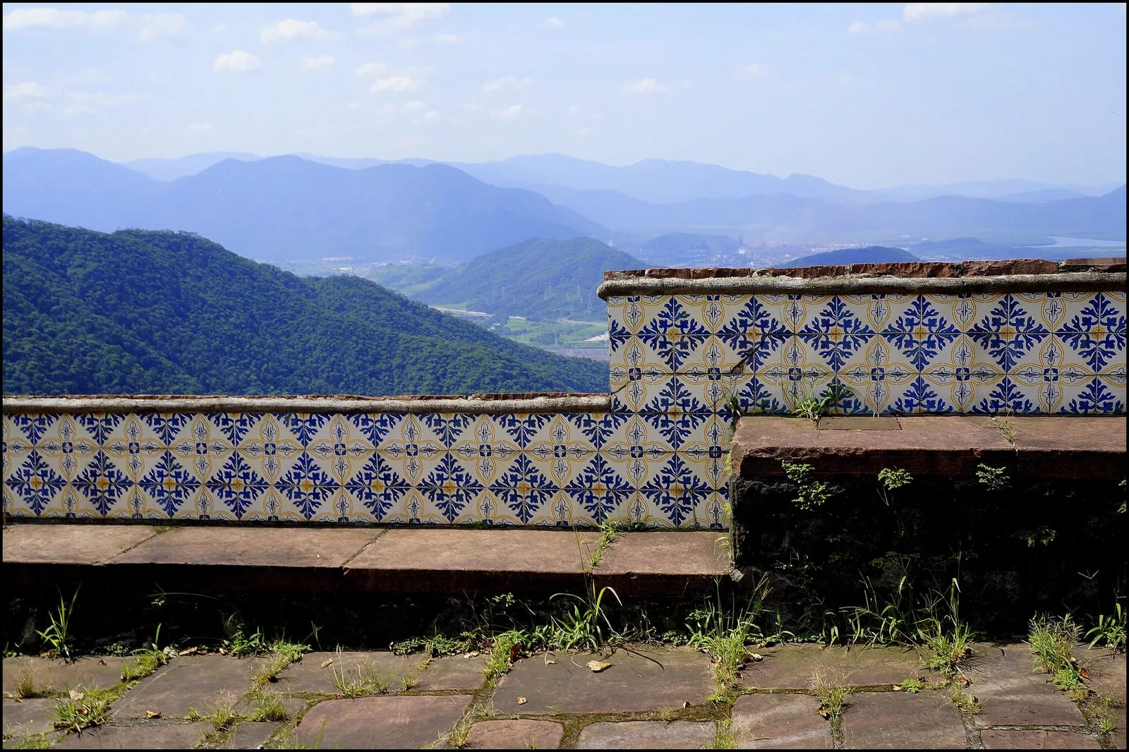
- Pouso Paranapiacaba and its historic tiles
- Lookout points over the Baixada Santista
- Preserved stretches of Calçada do Lorena
- Pontilhão Raiz da Serra and Cruzeiro Quinhentista
- Reservatório Rio das Pedras, for quiet contemplation
🎒 Things to do
- Follow Estrada Caminho do Mar on the self-guided historic route
- Walk Calçada do Lorena, watching your footing on the stone surface
- Observe fauna and flora without leaving authorized areas
- Pause at the interpretive panels and monuments
- Book Trilha da Cachoeira da Torre for a more demanding route
✨ Recommended experiences
- Cultural half-day: enter via São Bernardo do Campo, visit Pouso Paranapiacaba, and plan the walk around the day’s entry cutoff.
- A day in the mountains: pair Calçada do Lorena in the morning with the historic route, using the internal van only for the return if needed.
- For a greater challenge: reserve Cachoeira da Torre in advance, leave with the group at the scheduled time, and allow about six hours for the activity.
- Family outing: focus on the paved stretch, the accessible gate facilities, and the rest stops; avoid pushing young children down the steep descent.
🍽️ Local cuisine
🎶 Soundtrack
- Saudosa Maloca — Adoniran Barbosa
- Ovelha Negra — Rita Lee
🎭 Local culture
🌿 Nature nearby
🌎 Biomes
🏞️ Natural features
🐾 Possible animals in the area
🌱 Possible plants in the area
📅 Best time to visit
From May through September, drier weather tends to make the route firmer; even in the cooler months, fog can reduce visibility on the upper slopes.
- ✅ Best time:
- May through September, for a lower likelihood of rain and more comfortable conditions for taking in the scenery.
- 🟡 Shoulder season:
- March and April, when the forest remains very green, although there may still be precipitation.
- 🔴 Less recommended:
- October to February, especially on days of intense rain, lightning or thunder.
- 📝 Notes:
- Operations may suspend visits during storms. Check same-day conditions and choose a route that suits the group’s level of preparedness.
🧭 Getting there
🏙️ Base city: São Bernardo do Campo, via the Riacho Grande district
✈️ Airport: Congonhas Airport, in São Paulo
- Via the São Bernardo do Campo entrance on SP-148, at km 42 (26 mi), in Alto da Serra.
- Via the Cubatão entrance on SP-148, at km 50 (31 mi), near Cruzeiro Quinhentista.
- From São Paulo, the park is about 40 km (25 mi) via the route indicated by park operations; plan ahead, as the final approach runs through the mountains.
- Entry to complete the historic route through to the other gate is allowed only until noon.
🚗 Local transportation
- The historic route can be walked and has an optional internal van for the ascent or descent, subject to availability.
- The van does not serve Calçada do Lorena or Trilha da Cachoeira da Torre.
- Visitors remaining on the historic route after 4:20 p.m. must take the paid internal transport.
ℹ️ Practical information
- 🏗️ Infraestrutura:
- good for a mountain park with controlled visitation
- 🏨 Hospedagem:
- The park offers camping by bay, subject to reservation and availability; São Bernardo do Campo, Cubatão, and Santos offer urban lodging alternatives.
- 🍴 Diet:
- Food trucks operate in the support area, and Café 1922 is at Pouso Paranapiacaba; bring a light snack for longer routes.
- 🧭 Guides and agencies:
- The historic and ecotourism routes are self-guided, with monitors at key points. Groups and schools may request monitoring; Cachoeira da Torre requires advance booking.
- 📶 Internet and signal:
- Wi-Fi is available in support areas. Cell coverage along the trails can vary by mountain stretch.
- 💰 Estimated cost:
- Standard admission: R$ 55.00 full fare and R$ 27.50 half fare. Internal transport: R$ 45.00 per person, subject to availability. Car or motorcycle parking: R$ 38.00. The online admission-and-transport package costs R$ 75.00 at the full fare and R$ 60.00 at the half fare; park operations may update these prices.
- 📝 Notes:
- Fixed and portable restrooms, drinking fountains, parking, hammocks, signage, rest areas, and monitors are part of the facilities. Check on the day whether any monument is under restoration or closed.
♿ Acessibilidade
Level: partial
The historic route is paved and is the most suitable option for people with limited mobility. Internal transport and restrooms at both gates are accessible; the road’s slope, however, calls for appropriate planning and support.
- Calçada do Lorena has uneven stones and is unsuitable for strollers.
- A stroller can be used on the paved stretch, but the steep descent calls for extra care.
- State specific needs in advance and confirm the operating condition of each facility.
⚠️ Safety
🚨 Real risks
- Fog and rapidly changing visibility in the mountains
- Wet or uneven footing, especially on Calçada do Lorena
- Steep descents and fatigue on longer routes
- Area closures or suspended visits during thunderstorms
✅ Recommended care
- Wear closed shoes with good grip.
- Bring water, sun protection, insect repellent, a rain jacket, and a bag for your own waste.
- Respect entry times, signage and monitors' instructions.
- Do not take shortcuts, enter closed areas, or approach waterfalls or rock faces.
⛔ When to avoid: Do not start the visit when thunderstorms are forecast or if there is insufficient time to complete the authorized route before closing.
📝 Checklist — what to bring
- Walking shoes or hiking boots
- Enough water for the length of the route
- Cap or hat and sunglasses
- Sunscreen and repellent
- Compact rain jacket
- Light snack
- Waste bag
- ID and proof of half-fare eligibility, where applicable
✈️ Travel tips
- Arrive early to allow for entry limits and choose your route unhurriedly.
- Buy or check your admission ticket before setting out, as promotions and availability can change.
- To cross the entire road between the gates, begin walking before noon.
- Separate the Calçada do Lorena from the Estrada Velha de Santos: they are different routes, with different surfaces and levels of effort.
- Do not bring pets, smoke, or remove plants, minerals, or other natural elements.
💡 Curiosidades
- The visitor area brings together eight commemorative monuments designed by the French architect Victor Dubugras.
- The historic route follows a paved road and may have internal van service; Calçada do Lorena, by contrast, is a stone path dating from 1792.
- Belvedere Circular takes its name from an Italian word associated with a beautiful view.
- Casa de Visitas, built in 1926, now supports visitors and houses material about Usina Henry Borden.
🤔 Did you know?
- Paranapiacaba means “high place from which one sees the sea,” a fitting origin for the view from the pouso over the mountains.
- Pouso Paranapiacaba served as a stop where automobiles could cool down during the crossing.
- Pontilhão Raiz da Serra retains a plaque recording the completion of the concrete paving under the government of Carlos de Campos.
- Water from Reservatório Rio das Pedras travels through tunnels and pipelines to the system connected to Usina Henry Borden in Cubatão.
📜 History and context
In the late 18th century, Calçada do Lorena was completed to make the link between Santos and the plateau more efficient. Decades later, Estrada Caminho do Mar was paved in concrete, completed in 1925, and remained an important road connection until Via Anchieta opened in 1947. The road returned to tourist use in 2002.
🌍 Global importance
The park lies within the UNESCO-recognized Atlantic Forest Biosphere Reserve. In that setting, the complex brings built heritage together with one of Brazil’s great biodiversity-conservation territories, offering visitors a local view of a landscape with worldwide significance.
🗺️ Quick map (orientation)
📌 Main base: São Bernardo do Campo entrance, on SP-148 at km 42 (26 mi)
🧭 Landmarks
📍 Nearby places
Pequenas descobertas
- Serra do Mar
- A chain of coastal mountains in southeastern Brazil; here, the stretch between São Bernardo do Campo and Cubatão.
- SP
- A Brazilian state: São Paulo.
- Estrada Velha de Santos
- The popular name for the former São Paulo–Santos connection, opened in the early 20th century.
- 1922
- Centenary of Brazilian Independence, from 1822 to 1922.
- Pouso Paranapiacaba
- A commemorative building overlooking the Baixada; a centenary landmark.
- Belvederes
- A set of works inaugurated in 1922 along the old road.
- Mata atlântica
- Humid tropical biome, with high biodiversity and dense forest.
- Museu a céu aberto
- A route with signs and markers that guide a visit without a compulsory guide.
- Sanduíche de mortadela
- A mortadella sandwich, an icon of São Paulo snack bars.
- Bolo de fubá com goiabada
- Moist cornmeal cake with melted guava paste.
- Cana
- Freshly pressed sugarcane juice, a sweet and refreshing drink.
- SP-148
- A state highway linking the plateau to the coast, accessed through specific ramps.
- Anchieta/Imigrantes
- Sistema Anchieta-Imigrantes: the principal links between São Paulo and Santos.
- Anchieta
- SP-150: a historic route to the coast, with lookout points.
- Imigrantes
- SP-160: tunnels and viaducts; the principal flow toward the coast.
Keep discovering
Culture